Home > Ryukyu Islands > Kume Island
Kume Island is located approximately 100 km west of Okinawa Island in the East China Sea. It has a coastline of about 53 km and an area of 59 km² and is the fifth-largest island in the Ryukyu Archipelago. It is one of the most fascinating islands in the Ryukyu Archipelago for exploring the relationship between biogeographic and geologic characteristics of survey sites and the coral genera that compose their reefs.
Please take a look at an aerial photograph of Kume Island. After departing from Naha Airport, aircraft soon pass over the Kerama Islands, and before long Kume Island appears. The western part of the island itself has a diamond-like shape and rises to an average elevation of about 310 m. The island's coastline drops steeply into the deep sea. On the northwestern coast is the Okinawa Prefectural Deep Sea Water Research Center, where deep seawater pumped up from a depth of 612 m is studied and utilized for purposes such as kuruma prawn aquaculture. Near Nishimezaki, where the airport is located, a branch of the Kuroshio Current arriving from the west divides into northern and southern flows before continuing eastward. Compared with the inhabited southern coast, the sparsely populated northern coast is characterized by cliffs exceeding 300 m, where several beautiful waterfalls can be seen.
The geographic appeal of this island lies in the fact that, on the eastern side of this uplifted rocky island, a coral sand cay known as Hatenohama extends for more than 5 km. The beauty of the Hatenohama sandbar attracts many visitors. The northern side of Hatenohama, like the island itself, is steep and exposed to strong currents, whereas the southern side consists of intricate sandy shallows with gentler water movement. Further south, Ojima Bay forms a calm coral reef environment. Are the coral genera that compose the reefs around the rocky island, the reefs of Hatenohama, the northern and southern sides of Hatenohama, and the reefs within Ojima Bay the same? Or do they differ from one another?
Hoping that eDNA would provide answers to these questions, the Kume Island eDNA-M survey was conducted on June 10, 2024. Meanwhile, visual surveys under the Monitoring Site 1000 Program were carried out on August 24–25, 2003 (for Kume Island, the two surveys were not conducted simultaneously). However, no major climatic events capable of dramatically altering the coral reef ecosystem occurred during the intervening period, and we therefore consider the two datasets to be directly comparable. Although the present study focused on shallow coral reefs ≤15 m, we have also surveyed coral communities at ten sites around Kume Island at depths of ≤ 80 m using underwater drones. Results of these mesophotic reef surveys will be presented in the near future in the “Coral eDNA Atlas: Mesophotic Reefs.”
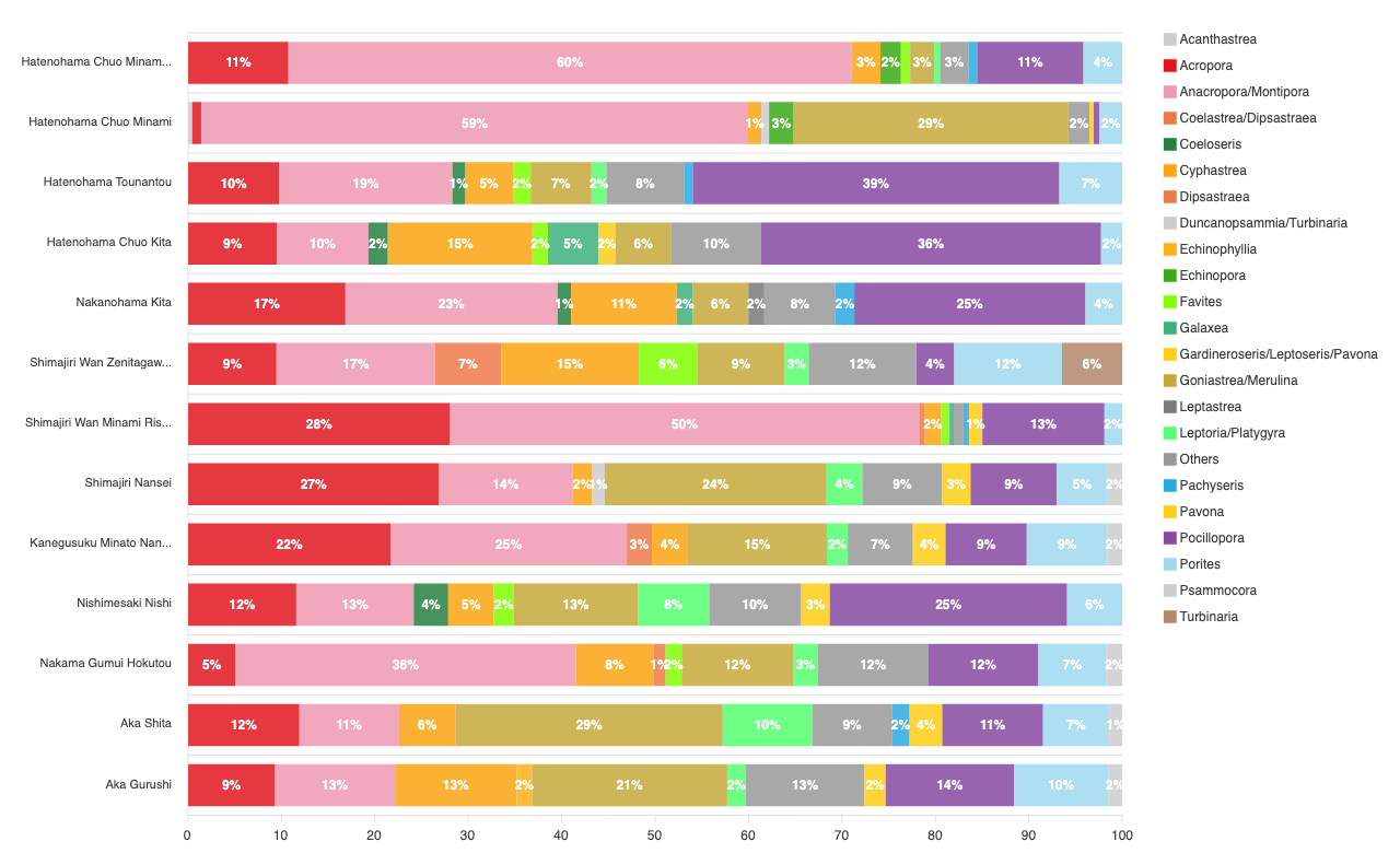
As shown in Figure 1B, the eDNA survey was conducted at 13 sites: seven sites around Kume Island (Sites 6 and 8–13), three sites on the northern side of Hatenohama (Sites 3–5), two sites on the southern side of Hatenohama (Sites 1 and 2), and one site in Ojima Bay (Site 7).
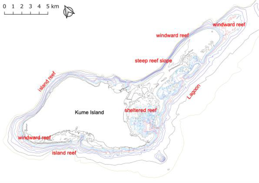
Physical geographic features of Kume Island.
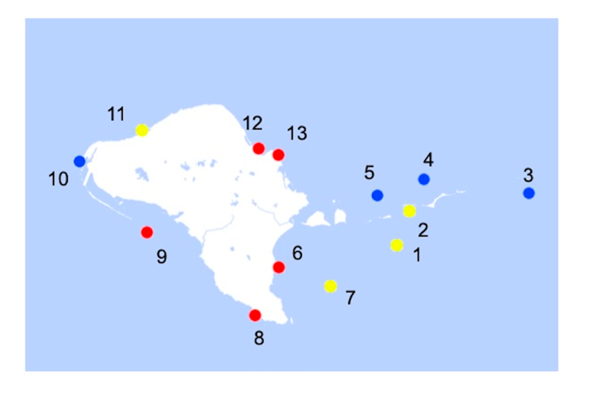
Similarity patterns among coral reefs based on the coral genera identified by eDNA-M analysis.
The results showed that the 13 coral reef sites around Kume Island can be broadly divided into three groups according to the coral genera that dominate each reef. The first group consisted of Sites 6, 8, 9, 12, and 13 around the main island (red circles), where Goniastrea and Merulina were the dominant genera. The second group included the three sites on the northern side of Hatenohama (Sites 3, 4, and 5) together with Site 10 on the western tip of the island (blue circles), where Pocillopora was the dominant genus. The third group comprised the three sites on the southern side of Hatenohama (Sites 1, 2, and 7) and Site 11 in the northwestern part of the island (yellow circles), where Montipora was the dominant genus.
These results suggest that biogeographic factors are associated with formation of coral reefs characterized by different proportions of coral genera. For example, Site 11 is situated in a relatively sheltered, gently sloped environment with limited wave exposure, conditions that resemble those of sites on the southern side of Hatenohama. In contrast, Site 10 is located on the wave-exposed western tip of the island and shares environmental characteristics with the northern Hatenohama sites, which are also exposed to strong wave action. Such similarities in environmental conditions may explain coral community patterns revealed by eDNA analysis.
 ミドリイシ属
(
Acropora
)
ミドリイシ属
(
Acropora
)
 トゲミドリイシ属
(
Anacropora
)
/
コモンサンゴ属
(
Montipora
)
トゲミドリイシ属
(
Anacropora
)
/
コモンサンゴ属
(
Montipora
)
 コカメノコキクメイシ属
(
Goniastrea
)
/
サザナミサンゴ属
(
Merulina
)
コカメノコキクメイシ属
(
Goniastrea
)
/
サザナミサンゴ属
(
Merulina
)
 ハナヤサイサンゴ属
(
Pocillopora
)
ハナヤサイサンゴ属
(
Pocillopora
)